The Wasatch Ride
 Ok Salt Lake City is
not Africa or the Greek islands but you know what? This was the
neatest place to rent a bike yet. Business took me to Salt Lake
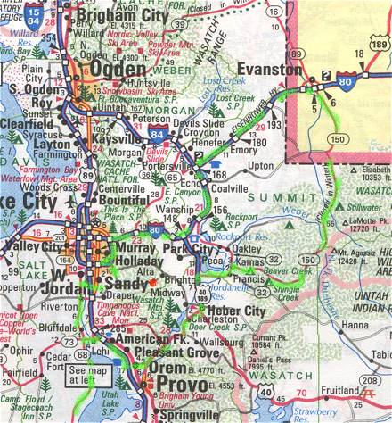
City in June of 2000. The conference was in the Snowbird Village,
a ski resort in the Wasatch Mountains just outside Salt Lake
City. The weather was perfect for early June and my schedule gave
me a free day. A quick look at the phone book showed Hawgs Wild (no longer in business)
under the heading of motorcycle rentals. That had
to be Harleys. Actually there were about 4 listings for
motorcycle rentals but this one was in Sandy, a suburb just at
the foot of my mountain. I called and sure enough they had a 98
Road Glide available, the price was right ($149 a day including
insurance) and they could pick me up at the lodge in 15 minutes.
Hawgs Wild is a husband and wife business run by Leonard and
Denise Kirk. Leonard has a fleet of 4 late model
big twins, two Road Glides, a Road King and a Heritage Soft Tail.
Their web site only advertises organized tours but they do rent
bikes by the day. Denise handled the paperwork and showed me the
workings of the peculiar Harley ignition and key system. After
she and gave me a helmet, some quick directions of what might be
an interesting ride and a Utah state map, off I went.
Ok Salt Lake City is
not Africa or the Greek islands but you know what? This was the
neatest place to rent a bike yet. Business took me to Salt Lake
City in June of 2000. The conference was in the Snowbird Village,
a ski resort in the Wasatch Mountains just outside Salt Lake
City. The weather was perfect for early June and my schedule gave
me a free day. A quick look at the phone book showed Hawgs Wild (no longer in business)
under the heading of motorcycle rentals. That had
to be Harleys. Actually there were about 4 listings for
motorcycle rentals but this one was in Sandy, a suburb just at
the foot of my mountain. I called and sure enough they had a 98
Road Glide available, the price was right ($149 a day including
insurance) and they could pick me up at the lodge in 15 minutes.
Hawgs Wild is a husband and wife business run by Leonard and
Denise Kirk. Leonard has a fleet of 4 late model
big twins, two Road Glides, a Road King and a Heritage Soft Tail.
Their web site only advertises organized tours but they do rent
bikes by the day. Denise handled the paperwork and showed me the
workings of the peculiar Harley ignition and key system. After
she and gave me a helmet, some quick directions of what might be
an interesting ride and a Utah state map, off I went.
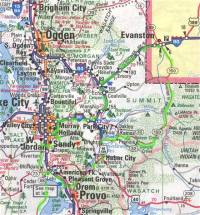
The first problem was that Hawgs Wild is
run out of the Kirk's House which is in a very large subdivision.
It was immediately obvious that I would have to figure out how to
get back there at the end of the ride. To complicate things
further Salt Lake City is not big on street names but rather
everything is by the numbers. Big numbers to boot. The main
street into the subdivision was simply 2300 west and about two
jillion south. Denise said a short cut to the main road was to
turn right go two blocks and right again (west) and go straight
until I hit State Street, the number zero north-south street.
Then from there I could find my way on the map. Block after block
of subdivision went by until I knew it was hopeless. I would
never be able to find my way back this way. I stopped and looked
for a pen so I could draw a map but did not have one so I said to
myself: memorize 2300! She lives just around the block from the
public school house on 2300! Armed with that I proceeded to State
Street and hoped for the best. Besides that problem was a full 8
hours away. I jogged south on State until I came to a main
east-west street and took a right there. While the street numbers
may drive you crazy the square grid layout actually makes it
pretty easy to navigate.
 My
target was Redwood Dr which is a major north-south street that
turns into Utah 68 and goes down the west side of lake Utah, a
large lake south of Salt Lake City. Soon I eased on to Redwood.
Traffic was light and before long I was out of the city and
dodging big dump trucks full of very dusty dirt. The temperature
was about 95 degrees and the humidity was about -50. The
visibility in the desert was unbelievable. I could see the end of
the lake and the road going all around the lake. It looked about
5 miles to the end. After about 15 minutes of cruising at about
60 I noticed that the end of the lake hadn't gotten any closer.
It was actually about 40 miles to the end of the lake! The
visibility in the desert really makes things look much closer
than they are. I was getting hot and dry so I said so much for
the desert, lets go to the mountains. The desert dryness is not
only uncomfortable it can be down right dangerous. You can forget
your credit card or your hotel key but do not go anywhere in Utah
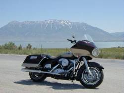
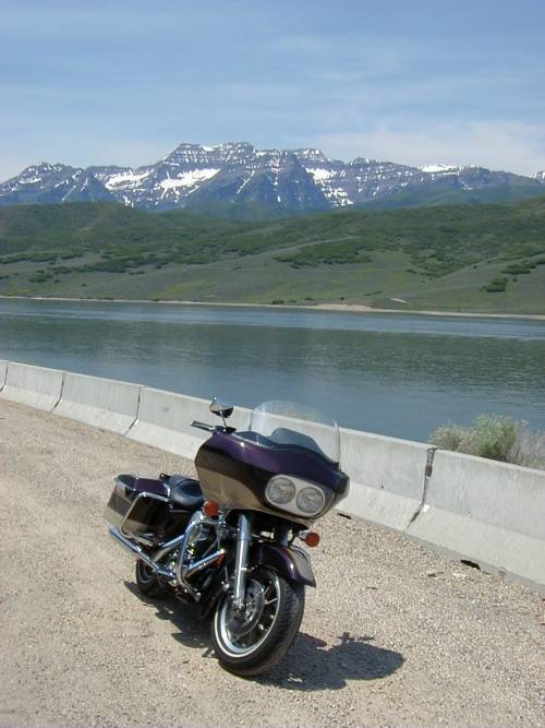
without a full bottle of drinking water! I turned around and got
off for a picture of the Road Glide with Lake Utah in the
background and then took a deep drink of water. That is Provo 20
miles across the lake.
My
target was Redwood Dr which is a major north-south street that
turns into Utah 68 and goes down the west side of lake Utah, a
large lake south of Salt Lake City. Soon I eased on to Redwood.
Traffic was light and before long I was out of the city and
dodging big dump trucks full of very dusty dirt. The temperature
was about 95 degrees and the humidity was about -50. The
visibility in the desert was unbelievable. I could see the end of
the lake and the road going all around the lake. It looked about
5 miles to the end. After about 15 minutes of cruising at about
60 I noticed that the end of the lake hadn't gotten any closer.
It was actually about 40 miles to the end of the lake! The
visibility in the desert really makes things look much closer
than they are. I was getting hot and dry so I said so much for
the desert, lets go to the mountains. The desert dryness is not
only uncomfortable it can be down right dangerous. You can forget
your credit card or your hotel key but do not go anywhere in Utah
without a full bottle of drinking water! I turned around and got
off for a picture of the Road Glide with Lake Utah in the
background and then took a deep drink of water. That is Provo 20
miles across the lake.
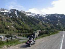
 I
back tracked to 73 and went east 5 miles to pick up I-89. I took
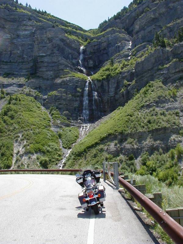
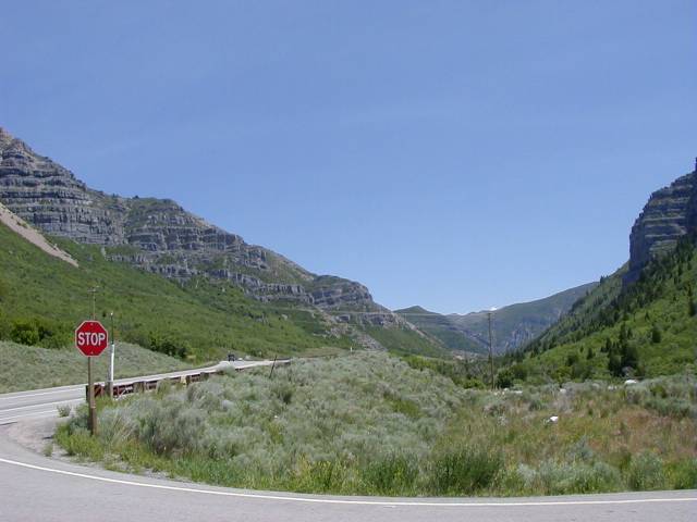
the freeway down to Orem where I got on the Provo Canyon Road. Now that is a road! It is a beautiful parkway with
towering cliffs on either side. I stopped to take a picture of a
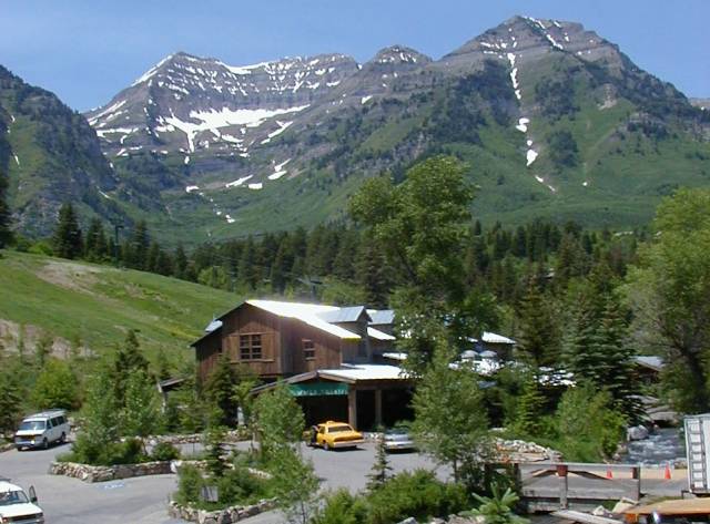
majestic waterfall careening down the canyon wall. About 10 miles
up the drive I came to the road to Sundance of Robert Redford
fame. I had to see that. It was only 3 or 4 miles up the mountain
to the resort. I took a picture of the Sundance summer theater. Back on the main road I skirted a big reservoir (Deer Creek??) with rugged snowcapped mountains in
the background. Sorry my map didn't give a name for the
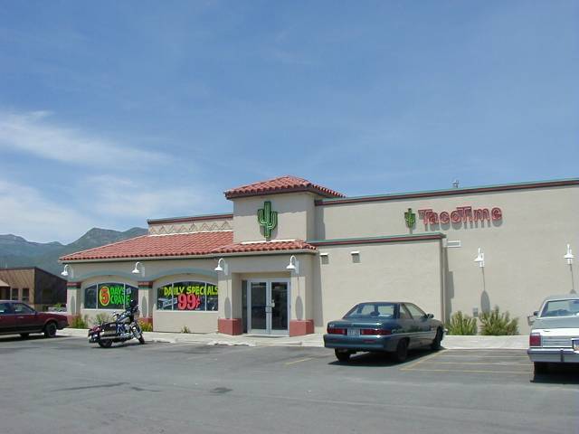
reservoir. I made my way into Heber City where I treated myself
to a taco for
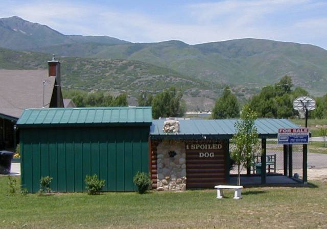
lunch. Coming into Heber City I saw
what had to be the fanciest doghouse I
ever saw. The sign on the doghouse says it all. Eat your hearts
out Jim and Tammy!
I
back tracked to 73 and went east 5 miles to pick up I-89. I took
the freeway down to Orem where I got on the Provo Canyon Road. Now that is a road! It is a beautiful parkway with
towering cliffs on either side. I stopped to take a picture of a
majestic waterfall careening down the canyon wall. About 10 miles
up the drive I came to the road to Sundance of Robert Redford
fame. I had to see that. It was only 3 or 4 miles up the mountain
to the resort. I took a picture of the Sundance summer theater. Back on the main road I skirted a big reservoir (Deer Creek??) with rugged snowcapped mountains in
the background. Sorry my map didn't give a name for the
reservoir. I made my way into Heber City where I treated myself
to a taco for
lunch. Coming into Heber City I saw
what had to be the fanciest doghouse I
ever saw. The sign on the doghouse says it all. Eat your hearts
out Jim and Tammy!
The Road Glide was wonderful. It had 20k on
the clock but looked like new. The rubber-mounted single-cam
motor was absolutely quiet and vibration free except at idle when
it looked like it was trying to escape from the frame. The engine
was fuel injected and throttle response was linear. I hate loud
pipes but this one had stock mufflers and was quieter than my
BMW. Only when you accelerated hard did you hear a pleasant ka ka
ka ka come singing from behind. The efficient fairing and quiet
propulsion made the radio quite usable and I enjoyed some very
relaxing Mozart as I made my way to Kamas. At Kamas I picked up
150 which makes its way into the Wasatch National Forrest. From
Kamas my destination was Evanston, 80 miles ahead. The National
Forest was great. The towering peaks gave way to low mountains
and dense
forest as the road followed the
Provo River to its source at the top of Bald Mountain. There was
a big sign that said road closed 14 miles ahead. I stopped at the
ranger station and they confirmed that the road was still closed
as they do not clear the snow in winter months. Snow? It was 90
degrees for goodness sake! I asked if I could go the 14 miles and
they said sure. At 14 miles I passed a road closed sign but saw
only clean dry road ahead and occasional traffic coming the other
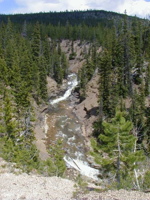
way so I kept going. The road lead steadily up. Around one turn
was Slate
Gorge where the Provo river had cut
deep into the slate canyon walls.
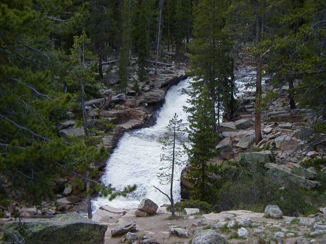
 A
few miles further I came to a large waterfall on the
provo river. Occasional traffic was still coming from ahead so I
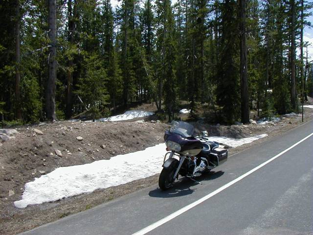
kept going. Soon I was in snow although it was
still about 65 degrees. I thought about getting my jacket out of
the bags but it wasn't that cool so I kept climbing. This stretch
of road was lined by many beautiful alpine lakes. I stopped and
took a picture of Lilly Lake. All it needed was a moose standing
in the shallows to be complete. Unfortunately he was nowhere to
be seen that day (although I am told that there are plenty up
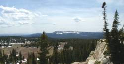
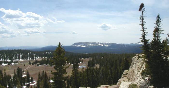
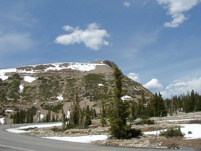
there). Finally the highest point was Bald Mountain pass. The road was clear with only a patch of snow here
and there which I could easily weave through. I didn’t want
to loose the big Road Glide on an icy spot as I had $1000
deductible insurance going for me. Not a problem though. I
stopped and took a nice panoramic picture from Bald Mountain
pass. The peak itself rises only several hundred more feet above
the roadway. I am not sure of the altitude but I would estimate I
was at 11,000 feet.
A
few miles further I came to a large waterfall on the
provo river. Occasional traffic was still coming from ahead so I
kept going. Soon I was in snow although it was
still about 65 degrees. I thought about getting my jacket out of
the bags but it wasn't that cool so I kept climbing. This stretch
of road was lined by many beautiful alpine lakes. I stopped and
took a picture of Lilly Lake. All it needed was a moose standing
in the shallows to be complete. Unfortunately he was nowhere to
be seen that day (although I am told that there are plenty up
there). Finally the highest point was Bald Mountain pass. The road was clear with only a patch of snow here
and there which I could easily weave through. I didn’t want
to loose the big Road Glide on an icy spot as I had $1000
deductible insurance going for me. Not a problem though. I
stopped and took a nice panoramic picture from Bald Mountain
pass. The peak itself rises only several hundred more feet above
the roadway. I am not sure of the altitude but I would estimate I
was at 11,000 feet.
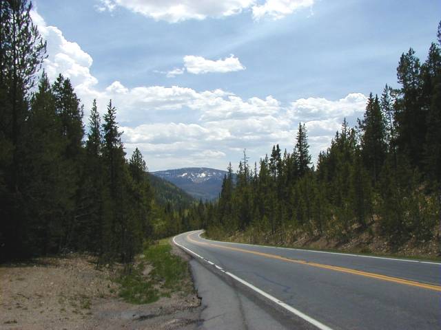
Now it was down hill. The road was good,
the curves gentle and the speedo kept creeping up to 70. Soon the
Mountains gave way to dense forest and then all of a sudden I was
in prairie. Miles and miles of green rolling prairie dotted with
farms unfolded before me. Herds of cattle sheep and horses could
be seen grazing on either side of the road. This is big country.
Now the road was arrow straight and deserted. The big twin pushed
effortlessly up to 80 and I watched the countryside glide by.
Sorry I didn't get a picture of this stretch. Along about here I
passed a "Welcome to Wyoming" sign. I motored my way up
to Evanston. Where I put 4 gallons of Sinclair premium in the
Road Glide. I hadn't seen Sinclair gas (that’s the one with
the big green brontosaurus for a logo) since I was a Kid. I had
thought that Sinclair Oil Co had gone the way of the hula hoop. I
also bought a roll of Halls cough drops to try to moisten my very
parched throat. I was 200 miles into my trip at this point.
 At Evanston I picked
up the Interstate for the 80-mile drive home. Traffic rolled
along at about 70 but here I encountered some fierce headwinds
with no mountains to slow them down. For about 40 miles I was
blown around and the big evo engine seemed to be saying "do
we have to do this". On a few uphill stretches I dropped
down into 4th to give the engine a break. There was
lots of ka ka ka ka coming out of those pipes now! After about 40
minutes the terrain became mountainous again and that broke the
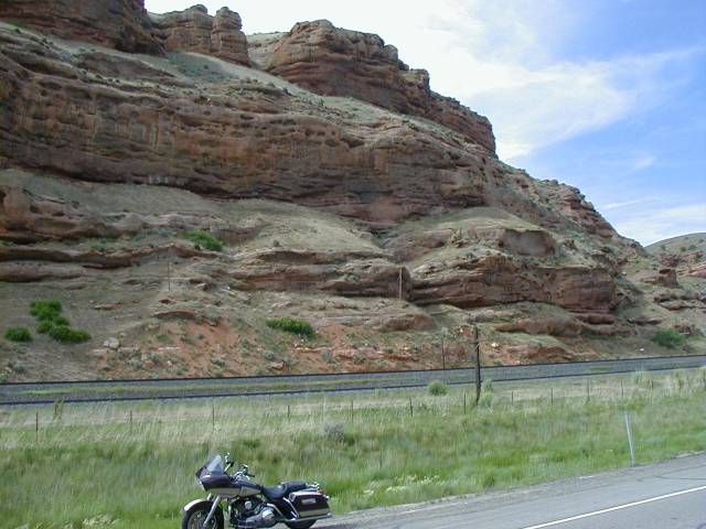
wind considerably. Approaching the town of Echo there was a huge
wall of sandstone
cliffs of to my right for mile
after mile. The source of the name echo was obvious. I tried a
toot of the horn to test the echo but the Harley's hooter was
pathetic. I could have farted louder. I found an exit to get a
picture but by that time the cliffs were much less impressive.
Motoring on I was back in the mountains with long uphill grades
followed by long downhill runs. There were gentle sweeping curves
and great views of the valley below which was filled with
picturesque villages and lakes. I-80 soon ran into I-215 and
before I knew it I was back in City Traffic.
At Evanston I picked
up the Interstate for the 80-mile drive home. Traffic rolled
along at about 70 but here I encountered some fierce headwinds
with no mountains to slow them down. For about 40 miles I was
blown around and the big evo engine seemed to be saying "do
we have to do this". On a few uphill stretches I dropped
down into 4th to give the engine a break. There was
lots of ka ka ka ka coming out of those pipes now! After about 40
minutes the terrain became mountainous again and that broke the
wind considerably. Approaching the town of Echo there was a huge
wall of sandstone
cliffs of to my right for mile
after mile. The source of the name echo was obvious. I tried a
toot of the horn to test the echo but the Harley's hooter was
pathetic. I could have farted louder. I found an exit to get a
picture but by that time the cliffs were much less impressive.
Motoring on I was back in the mountains with long uphill grades
followed by long downhill runs. There were gentle sweeping curves
and great views of the valley below which was filled with
picturesque villages and lakes. I-80 soon ran into I-215 and
before I knew it I was back in City Traffic.
 Now
I was suddenly faced with how do I get back to the Kirk's house
to return the bike? The problem was soon solved as an exit came
up for Snowbird (where I was staying). I took the exit and
followed the signs and soon was on Cottonwood Canyon Road on the
way up the mountain to Snowbird. I then passed Cotton Wood Canyon
Trail which was where we had turned off that morning. By the way,
in June the cottonwood trees are in bloom and the blowing cotton
fills the air like gentle snow. There was real hope now that I
could find my way to turn in the bike. I went on up to Snowbird
with the hope that someone I knew might spot me on the Harley
(nobody did). Snowbird is located in the town of Alta which you
can find on the map just to the right of Sandy. Actually the road
up to Snowbird was as pretty as any I had been on that day. Its
funny how more beautiful things look from a bike than from a cab.
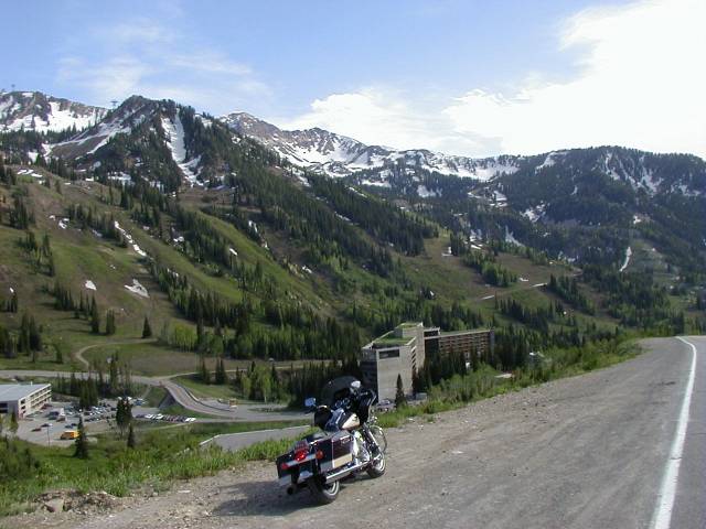
At Snowbird I took one last picture of The Road Glide with the
slopes of Snowbird and the Cliff Lodge where I was staying in the
background. I then motored down the mountain, turned on
Cottonwood trail and rode until I came to that magic number 2300.
I hung a left and rode 5 or 6 blocks to the school and then a
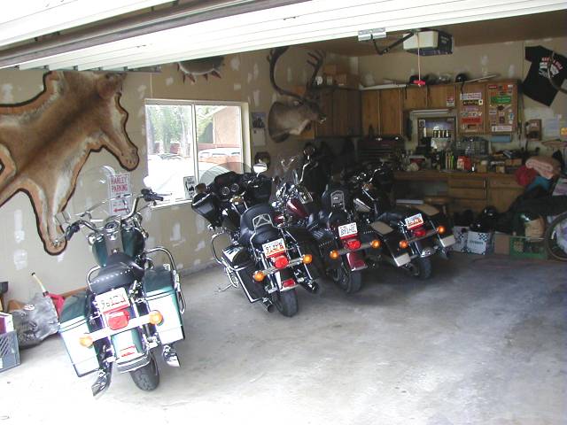
right turn and right into the Kirk's Driveway. Once in the
general vicinity the Kirk's house was easy to identify by the 55
Chevy project car next to the garage. The three Harleys in the
driveway also helped.
Now
I was suddenly faced with how do I get back to the Kirk's house
to return the bike? The problem was soon solved as an exit came
up for Snowbird (where I was staying). I took the exit and
followed the signs and soon was on Cottonwood Canyon Road on the
way up the mountain to Snowbird. I then passed Cotton Wood Canyon
Trail which was where we had turned off that morning. By the way,
in June the cottonwood trees are in bloom and the blowing cotton
fills the air like gentle snow. There was real hope now that I
could find my way to turn in the bike. I went on up to Snowbird
with the hope that someone I knew might spot me on the Harley
(nobody did). Snowbird is located in the town of Alta which you
can find on the map just to the right of Sandy. Actually the road
up to Snowbird was as pretty as any I had been on that day. Its
funny how more beautiful things look from a bike than from a cab.
At Snowbird I took one last picture of The Road Glide with the
slopes of Snowbird and the Cliff Lodge where I was staying in the
background. I then motored down the mountain, turned on
Cottonwood trail and rode until I came to that magic number 2300.
I hung a left and rode 5 or 6 blocks to the school and then a
right turn and right into the Kirk's Driveway. Once in the
general vicinity the Kirk's house was easy to identify by the 55
Chevy project car next to the garage. The three Harleys in the
driveway also helped.
I settled my bill and thanks were said all
around. Denise drove me back up the mountain and I went to my
room and collapsed, tired, dusty and very happy. In all I had
driven 290 miles in about 8 hours. I had a little sunburn on my
arms but my face was not too bad. I learned my lesson in Greece
and made sure I had a bill on my helmet this time. Other than
looking at some knockout scenery I really did not have any
harrowing adventures on this trip. And that’s the way it
should be. Utah is in America for crying out loud! You can spend
your American money there, the people speak your language and
they are friendly. What more could you ask for? Of course you
could encounter one of those moose or bears or mountain
lions…..
Return to the Restoration Page
 Ok Salt Lake City is
not Africa or the Greek islands but you know what? This was the
neatest place to rent a bike yet. Business took me to Salt Lake
City in June of 2000. The conference was in the Snowbird Village,
a ski resort in the Wasatch Mountains just outside Salt Lake
City. The weather was perfect for early June and my schedule gave
me a free day. A quick look at the phone book showed Hawgs Wild (no longer in business)
under the heading of motorcycle rentals. That had
to be Harleys. Actually there were about 4 listings for
motorcycle rentals but this one was in Sandy, a suburb just at
the foot of my mountain. I called and sure enough they had a 98
Road Glide available, the price was right ($149 a day including
insurance) and they could pick me up at the lodge in 15 minutes.
Hawgs Wild is a husband and wife business run by Leonard and
Denise Kirk. Leonard has a fleet of 4 late model
big twins, two Road Glides, a Road King and a Heritage Soft Tail.
Their web site only advertises organized tours but they do rent
bikes by the day. Denise handled the paperwork and showed me the
workings of the peculiar Harley ignition and key system. After
she and gave me a helmet, some quick directions of what might be
an interesting ride and a Utah state map, off I went.
Ok Salt Lake City is
not Africa or the Greek islands but you know what? This was the
neatest place to rent a bike yet. Business took me to Salt Lake
City in June of 2000. The conference was in the Snowbird Village,
a ski resort in the Wasatch Mountains just outside Salt Lake
City. The weather was perfect for early June and my schedule gave
me a free day. A quick look at the phone book showed Hawgs Wild (no longer in business)
under the heading of motorcycle rentals. That had
to be Harleys. Actually there were about 4 listings for
motorcycle rentals but this one was in Sandy, a suburb just at
the foot of my mountain. I called and sure enough they had a 98
Road Glide available, the price was right ($149 a day including
insurance) and they could pick me up at the lodge in 15 minutes.
Hawgs Wild is a husband and wife business run by Leonard and
Denise Kirk. Leonard has a fleet of 4 late model
big twins, two Road Glides, a Road King and a Heritage Soft Tail.
Their web site only advertises organized tours but they do rent
bikes by the day. Denise handled the paperwork and showed me the
workings of the peculiar Harley ignition and key system. After
she and gave me a helmet, some quick directions of what might be
an interesting ride and a Utah state map, off I went.